TERRITORY
The Bordeaux Wine GIS: an interprofessional digital mapping tool for professionals and collective management of the Bordeaux vineyards
The Bordeaux Wine Council (CIVB) has developed the Bordeaux Wine GIS, a collaborative mapping application designed for all professionals in the sector. This digital tool enables the centralization, visualization, and analysis of spatial data relating to the Bordeaux vineyards.
FRANCE
AREA TO BE DIGITISED
Production Processes
SUBSECTOR #1
Agriculture
SUBSECTOR #2
Vineyard winemaking
CROP PRODUCTION SYSTEM 1, 2, 3
N/A (Not applicable)
N/A (Not applicable)
N/A (Not applicable)
TECHNOLOGY
Location based technologies/systems
DIGITAL SOLUTION CATEGORY
Production process management
STAKEHOLDERS
Local and regional administrations
IMPACT
Productivity
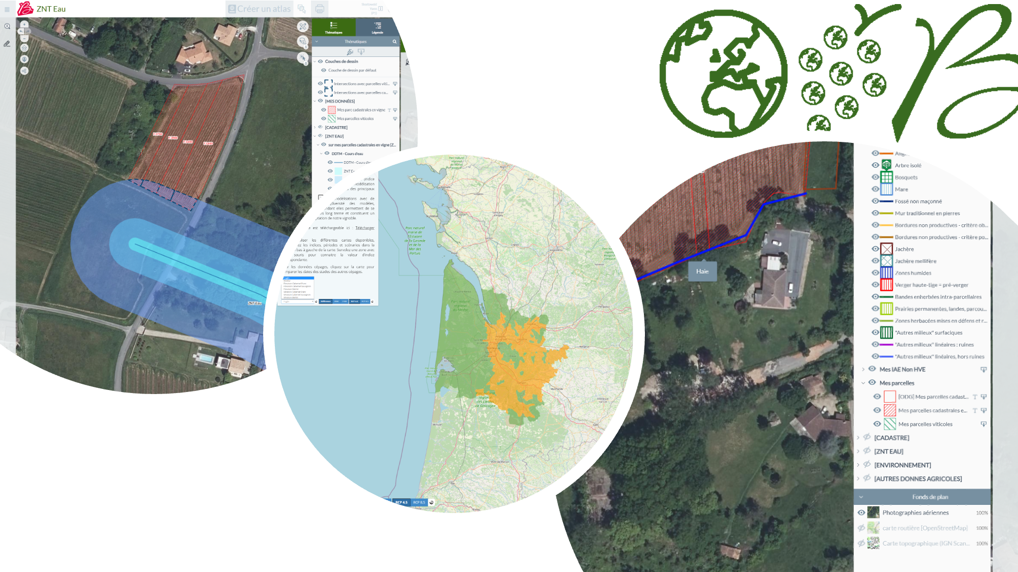
The Bordeaux Wine Council (CIVB) has developed the Bordeaux Wine GIS, a collaborative mapping application designed for all professionals in the sector. This digital tool enables the centralization, visualization, and analysis of spatial data relating to the Bordeaux vineyards. At the interprofessional level, the GIS is a strategic lever for knowledge, management, and support for the agroecological transition, facilitating vineyard monitoring, collective decision-making, and the deployment of targeted actions.
Farm challenges
Across the Bordeaux wine region, the industry and its interprofessional organization face major structural challenges :
– Heterogeneity of agronomic, climatic, and health conditions across a vast and diverse territory
– Need for reliable, shared, and up-to-date data to guide interprofessional policies
– The role of the interprofessional organization in supporting environmental transition (reduction of inputs, certifications, adaptation to climate change)
– Monitoring developments in the vineyards (areas, practices, grubbing-up, replanting)
– The need to strengthen coordination between stakeholders (winegrowers, technicians, organizations, institutions)
With the aim of significantly improving its knowledge of the vineyards through specialized data in order to carry out its missions, and with the goal of providing a mapping application that makes it easy to create all types of maps useful to professionals in the sector, the CIVB has developed the Bordeaux Wine GIS: a mapping tool for monitoring vineyards that is accessible to all professionals and provides a wealth of specialized data.
The Bordeaux Wine GIS covers a wide range of topics addressing the main challenges currently facing viticulture. These include:
– regulatory and environmental issues (ZNT, safety distances for residents and people present),
– parcel and cadastral management,
– biodiversity (bats, flora),
– agroecology and High Environmental Value initiatives (Agroecological Infrastructure, Topographic Equivalent Area calculation),
– vineyard health issues (sanitary vine « grubbing-up »),
– adaptation to climate change (agroclimatic atlas),
– knowledge of soils and terroirs,
– collective and territorial initiatives led by defense and management organizations (ODG)*
* collective structure that supports the Appellation of Origin approach
Uses and needs covered:
The GIS meets very specific needs expressed by professionals, including:
– gaining a better understanding of the immediate environment of plots (neighbors, waterways, sensitive areas),
– securing and regulating phytosanitary practices,
– quickly producing reliable and enforceable regulatory documents,
– supporting certification processes (HVE, agroecology),
– facilitating information sharing and coordination at the collective level,
– providing objective data to support arguments and protect local areas in the face of development projects.
Target audiences :
The solution is primarily aimed at:
– professionals in the wine industry: winegrowers and merchants,
– Defense and Management Organizations (ODG) and certain Pest Control Groups (GDON),
– technical and institutional structures in the industry (FGVB, Chamber of Agriculture, etc.),
– partner administrations and organizations (DRAAF, DDTM), particularly on issues such as the sanitary « grubbing-up » of vines or the management of abandoned vineyards,
as well as certain external partners (environmental associations, technical organizations).
Assistance / Boost program
The Bordeaux Wine GIS is coordinated and managed by the CIVB (Bordeaux Wine Council), as part of its mission to structure, support, and plan for the future of the wine industry.
The project is based on:
- Interprofessional governance involving the various stakeholders in the industry
- Technical and scientific partnerships (research organizations, chambers of agriculture, technical bodies)
- A collective approach aimed at sharing data and digital tools for the benefit of the widest possible audience
The CIVB is responsible for the development, maintenance, management, and promotion of the GIS for professionals.
Innovative features of the initiative / solution
- The Bordeaux Wine Geographic Information System (GIS) is a web-based mapping platform dedicated to monitoring, analyzing, and managing the Bordeaux vineyards. Created in 2000, it is now a structured and sustainable tool that has been continuously evolving for more than 25 years, closely aligned with the needs of professionals in the industry.
- The innovation of the Bordeaux Wine GIS lies above all in its collective positioning. Unlike many digital solutions targeting a single operation or isolated use, the GIS was designed from the outset as a shared tool for the entire industry, integrating shared technical, regulatory, environmental, and territorial data.
- Functionally, the GIS is based on the systematic combination of three dimensions : the vineyard, through the plots, their surface areas, and their technical characteristics; the geographical dimension, enabling spatial analysis (location, distances, neighborhood, intersections); a targeted business theme, responding to concrete issues (regulation, environment, biodiversity, health, climate, forecasting).This approach makes it possible to offer genuine cartographic decision support tools (DSTs) that can be used both individually by winegrowers and collectively by ODG, technical structures, and institutions in the sector. Finally, the GIS stands out for its user-centric design, developed in collaboration with end users, and its high adaptability: ease of use, rapid access to information, application modularity, and agility in functional upgrades.
Results obtanied
- The deployment of the Bordeaux Wine GIS has delivered concrete and measurable results for users, both individually and collectively.For winegrowers, the GIS has contributed to:
– a better understanding of the regulatory environment for plots (ZNT, DSR, DSPPR),
– more secure practices thanks to a clear and up-to-date visualization of regulatory constraints,
– significant time savings in the production of cartographic and regulatory documents (automatically generated personalized atlases),
– a reduction in errors and approximations related to the interpretation of complex data. - For ODG, wine unions, and GDON, the solution has enabled:
– more effective collective management of vineyards at the appellation and regional levels,
– better coordination of health measures (grubbing-up, flavescence dorée, management of fallow land),
– access to shared spatial analyses, facilitating decision-making, and – support for members. - At the industry level, the Bordeaux Wine GIS has thus contributed to:
– strengthening the consistency and uniformity of practices,
– improving the dissemination of information and transparency,
– accelerating the collective digital transition of Bordeaux viticulture. - Usage statistics:
-1,800 different users used the GIS in 2025.
-14,200 visits.
– Average visit duration: 10 minutes.
Lessons learned
One of the main lessons learned from this project is that pooling data and tools across an entire sector is a powerful lever for digital transition. It enables the development of robust, consistent, and widely adopted solutions, whereas isolated approaches would be more costly and less effective.
The success of the GIS is also based on:
the close alignment between the features offered and the regulatory and operational needs of users,
the importance of automation (e.g., one-click atlas generation) to reduce administrative burden,
structured governance, particularly through the Technical Commission, which allows developments to be prioritized based on actual usage in the field.
Finally, experience shows that simplicity, data reliability, and the ability to continuously evolve are key factors in ensuring that a digital tool becomes a lasting part of professional practices.

